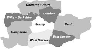
Click on a region to choose a walk.
Now with over 500 FREE detailed guides!
Beautiful free classic walks with fresh creative imagination. In fine detail, fully mapped, plus GPS, spiced with history. Many of these walks find completely new routes, making them different from the walks that you find in a book or on one of the more official websites. Some of them make use of legal permissive paths, commonland, free access areas and local village paths to reveal wonderful new routes and landscapes. Because these paths often change, this website is continually kept up-to-date, chiefly thanks to your feedback.
This website is a guide for people who love to walk, to observe and enjoy our incredible countryside (and townscapes too) at a leisurely speed. Distances vary from a soothing 1 mile=1½ km to a bone-shattering 41 miles=65 km.
If you like careful, precise directions all along the way, these walks are designed specially for you!
Our routes are found by sheer hard legwork, tracking, back-tracking and picking the best path out of many, not by sitting at home with a map!
Each walk is completely free. Just print it, download it or access it from your smartphone.
Before doing a walk, please read this advice page:
Click here for a Birds Eye View of all Walks in the South East
via Google Maps.
Help! Please see new Guidelines for Corrections on Feedback page.
Keep corrections brief please! See Feedback.
Help The Ramblers find lost paths!
We value your privacy -- that's why we mind our own beeping business.
Pubs: USE THEM!! (or LOSE them!)
Go walking by train! Look for the ⇌ sign in the listings.
Devil's Punch Bowl car park renovation summer 2021: expect reduced capacity.
Blocked paths? Ploughed-up fields? Broken stiles? Please contact the Local Authority.

Click on a region to choose a walk.